 More than 8 million people live, work and operate businesses in and on the Long Island Sound watershed. The activities that take place along and above the Sound – fishing, boating, tourism, recreation and swimming – contribute an estimated $8.91 billion per year to the regional economy, according to the Long Island Sound Study (in 2011 dollars).
 The waters also provide feeding, breeding, and nesting areas for a diversity of plant and animal life. The water views and quality of life along the shoreline are an additional economic factor.
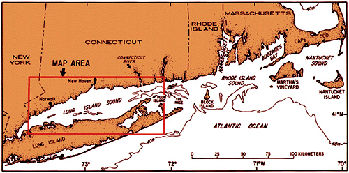
The Sound’s coastline stretches more than 600 miles and is technically defined as the waters between Connecticut and Long Island, New York – ending as the sea flows east to Rhode Island with multiple inlets and becomes the Atlantic Ocean, proper.
Now the acreage under those waters are getting scrutinized by a fleet of scientists, students and government agencies bent on capturing as complete a picture as possible about the entire region – geology, biology, seasonal usage, infrastructure.
Funding for the project comes from a settlement fund established in 2004 after a lengthy conflict among utility companies and state governments over the placement and repair of the Cross-Sound Cable, a 24-mile submarine cable buried in Long Island Sound that connects the electric transmission grids of New England and Long Island, New York.

The U.S. Geologic Survey, National Oceanic and Atmospheric Administration (NOAA), the Northeast Undersea Research Technology and Education Center at University of Connecticut, and Long Island Sound Mapping and Research Collaborative (LISMaRC), which is a partnership between University of Connecticut, the University of New Haven, and the University of Rhode Island, will participate along with students from Wesleyan University, Stony Brook University, Columbia University and the City University of New York. Additionally, the Connecticut DEEP and Sea Grant offices in New York will work with the EPA and interface with all others.
NOAA’s Thomas Jefferson, part a fleet of mapping vessels, performs hydrographic surveys. According to NOAA, the sea floor composition creates implications for “anchoring, dredging, structure construction, pipeline and cable routing and fisheries habitat.”